Commercial real estate transactions require rigorous due diligence to safeguard substantial capital investments. In Trumbull County, Ohio, failing to identify a hidden legal restriction on a commercial lot can completely halt a development project. Commercial easements and Right-of-Way (ROW) restrictions represent legally binding property rights held by utility companies, neighboring businesses, or municipal entities. Because these structural overlays dictate exactly where you can and cannot build, mastering local land databases is crucial. This expert-level technical guide outlines the specific procedures required to locate, audit, and analyze commercial boundary encumbrances utilizing the legal framework managed by Ohio county authorities.
The Legal Nature of Commercial Easements and Right-of-Way in Ohio
Under the Ohio Revised Code (ORC), a commercial easement is a nonpossessory interest in another party’s land that allows the holder to use the parcel for a specified, limited purpose. Unlike residential utility access, commercial easements often involve major high-voltage transmission corridors, large-scale regional drainage basins, or shared industrial transport roads.
Easements Appurtenant vs. Easements in Gross
Commercial developments frequently deal with easements appurtenant, which legally “run with the land.” This means the restriction remains tied to the parcel number regardless of ownership changes. Conversely, an easement in gross grants a specific commercial entity or utility corporation a personal right to use the land, which cannot easily be transferred without structured legal reviews.
Understanding Right-of-Way (ROW) Restrictions
A Right-of-Way is a distinct type of easement that grants public or private entities the right to pass through a designated strip of your real estate. In Trumbull County, municipal expanded roadway zones, highway buffers, and railway access corridors are classified as ROWs. Building permanent commercial structures over a designated ROW is strictly prohibited and can result in mandatory demolition at the owner’s expense.
Administrative Infrastructure: Trumbull County vs. Stark County Records
When executing commercial due diligence, it is vital to know which county office maintains specific data sets. Under Ohio state law, land records are managed through an independent system of checks and balances involving the County Auditor, the County Engineer’s Tax Map Department, and the County Recorder.
For example, the Trumbull County GIS and Tax Map Department manages the spatial infrastructure, tax maps, and parcel splits across local municipalities. When analyzing complex commercial sites, looking at neighboring structural models provides an excellent benchmark.
The table below demonstrates how administrative systems divide responsibility when tracking real estate encumbrances, ensuring title teams utilize the correct guide for auditor services:
| County Administrative Authority | Core Mapping & GIS Layer Scope | Real Estate Encumbrance Accountability | Property Document Processing Workflow |
| Trumbull County Auditor & Tax Map Dept. | Manages public GIS portals, interactive tax maps, and parcel numbers. | Tracks structural acreage adjustments and verifies legal parcel descriptions. | Enforces strict conveyance rules for surveys and new deed transfers. |
| Stark County Auditor | Administers countywide property records and fiscal assessments. | Maintains an independent guide for auditor services and automated mapping tracking. | Disburses accurate public tax documents and updates primary valuation registries. |
| Trumbull County Recorder | Indexes physical deeds, historic plats, and restrictive covenants. | Serves as the primary legal archive for recorded easement contracts. | Houses recorded metes-and-bounds survey books and public lien registries. |
Step by Step Guide: Auditing Easements on Trumbull County Portals
To uncover hidden boundary restrictions on a commercial parcel before closing a transaction, follow this professional step-by-step auditing sequence.
Step 1. Extracting the Permanent Tax Parcel Number: ID Procurement.
Access the Trumbull County property search engine. Input the commercial site address or owner entity name to retrieve the unique, permanent multi-digit tax parcel ID number required for advanced mapping.
Step 2. Launching the GIS Interactive Community Map Viewer: GIS Spatial Audit.
Open the Trumbull County GIS Open Data Portal. Input your parcel ID to zoom to the property boundaries. Activate administrative map layers, including centerlines, corporate limits, and regional utility corridors.
Step 3. Reviewing the Tax Map Department Plat Records: Survey History Check.
Examine the county tax map directly inside the portal interface. Check if the property boundary lines contain specific notations such as “Subject to Right-of-Way” or indicate a recorded survey volume and page number.
Step 4. Cross-Referencing via the Recorder’s Document Index: Deed Reconciliation.
Take the legal description and prior deed references found in the auditor’s system to the Trumbull County Recorder’s online indexing platform. Pull up the historical deed images to read the precise metes-and-bounds language defining the easement.
Technical Calculations: Assessing Impact on Commercial Buildable Area
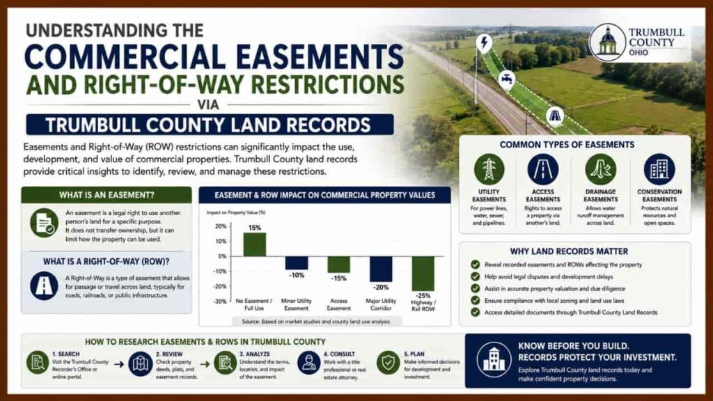
Commercial investors must understand that easements directly reduce a parcel’s net developable area. When calculating the usable footprint of a commercial site, the total square footage of all overlapping easements and setback zones must be deducted from the gross parcel acreage.
Net Developable Area = Gross Parcel Area – Easement Area + Zoning Setbacks
If a commercial parcel in Warren, Ohio, has a gross area of 87,120 square feet (2 acres), but features a 50-foot wide regional pipeline easement running along the rear boundary spanning 15,000 square feet, that specific acreage is permanently restricted. You cannot place building foundations, stormwater retention ponds, or permanent structures inside that zone.
Critical Solutions for Resolving Commercial Easement Conflicts
If your land audit reveals an unexpected easement that threatens your proposed commercial layout, consider these professional remedies:
- Negotiate an Easement Vacation:
If a public right-of-way or utility corridor is old or no longer in use, you can file a formal petition for a vacation of the easement with the local city council or county commissioners. - Execute a Relocation Agreement:
You can negotiate with the easement holder (such as a utility provider) to physically relocate the infrastructure lines to the perimeter of the parcel, splitting the engineering costs. - Apply for a Variance:
If local zoning setbacks overlap awkwardly with a recorded easement, apply for an administrative variance with the local zoning board of appeals to alter your building footprint.
Conclusion
Auditing commercial easements and Right-of-Way restrictions via the Trumbull County Auditor and GIS portals is a critical due diligence step for local real estate investors. By actively utilizing spatial data tools, cross-referencing legal descriptions with the County Recorder, and understanding how these boundary lines reduce your net developable area, you can mitigate legal risks, protect your capital investments, and maintain full compliance under Ohio county governance frameworks.
How do I look up commercial easements in Trumbull County, Ohio?
You can identify potential encumbrances by entering the parcel ID into the Trumbull County GIS Interactive Map Viewer and checking the dedicated tax maps for dedicated roadway or utility boundary layers.
What is the difference between a property easement and a Right-of-Way?
An easement grants specific entities limited use of your land (like utilities), while a Right-of-Way explicitly permits public or private entities the right to pass through a designated strip of your property.
Can I build a commercial structure over a recorded utility easement?
No. Building permanent structures over utility easements or municipal Rights-of-Way is strictly prohibited and can result in mandatory, legal demolition of the structure at the property owner’s expense.
How do Trumbull and Stark County auditors differ in mapping land restrictions?
Both offices serve as independent fiscal watchdogs under Ohio law, using specialized CAMA systems and online service guides to manage property parcel records, tracking structural boundary adjustments transparently.
How can I remove an old, unused easement from my property parcel?
You can file a formal administrative petition for an easement vacation with the local city council, negotiate a relocation agreement with the utility holder, or seek a local zoning variance.